Another earthquake rattled NW Washington on Sunday. What’s causing quakes in Puget Sound?
Just weeks after a 4.3 magnitude earthquake rattled Puget Sound, some northwest Washington residents felt the ground beneath their feet shaking again Sunday night.
A 3.1 magnitude quake — strong enough to typically be felt by those on the surface — was detected by the Pacific Northwest Seismic Network (PNSN) about 29 kilometers beneath Wauna, about six miles from Gig Harbor.
Here’s what to know about Sunday night’s quake and why Puget Sound seems to get so many earthquakes.
Where was the quake felt?
The 3.1-magnitude earthquake was felt throughout Puget Sound on Sunday at 7:41 p.m., according to the U.S. Geological Survey (USGS).
The epicenter of the earthquake was 17.1 miles northwest of Tacoma, according to PNSN.
Over 170 people reported feeling the earthquake to the U.S. Geological Survey. Almost all the responses said the earthquake’s intensity was at level 1 or 2 on the Modified Mercalli Intensity (MMI) scale, meaning there was very light shaking. The MMI scale estimates the intensity of an earthquake based on the severity of ground shaking and the effects of the shaking on people, buildings, and landscapes.
According to the USGS, one person in Puyallup reported feeling the shaking from the earthquake at a higher intensity and categorized it as level 4, meaning most people indoors would feel the quake, and many outside would notice cars shaking. In contrast, two people in Gig Harbor classified the shaking as a level 1.
Why does Puget Sound feel so many earthquakes?
The Puget Sound region is built on two prominent fault lines — the Seattle and Tacoma Faults.
The Seattle Fault Zone passes directly under Seattle and follows approximately the same path as Interstate 90. It’s responsible for some of the largest earthquakes in the region in recent memory, such as the Tacoma 6.7 magnitude earthquake in 1965 and the 6.8 magnitude Nisqually earthquake in 2001.
The Tacoma Fault is a series of smaller connecting fault lines, which are cracks along the surface of the Earth where earthquakes typically occur. The primary fault line within the Tacoma Fault Zone is a 35-mile-long rupture between Kent and Union.
The fault zone is responsible for many of Puget Sound’s more minor quakes and is capable of producing a quake up to 7.0 in magnitude, according to a study by the Washington Military Department.
“Our chances of a magnitude seven earthquake happening are probably more than people think,” Harold Tobin, director of PNSN and professor at the University of Washington’s Department of Earth and Space Sciences, previously told McClatchy News.
Tobin believes the chances of a 7.0 magnitude occurring in the Puget Sound region within the next 30 years stand as high as 80-85%. He notes that the same stat can be relevant for periods as far as 50 or 100 years, but 30 years is used as a benchmark because it’s about the length of a generation and easier for people to wrap their minds around.
There’s also the possibility of what seismologists call “The Big One.”
The North American Plate — a vast tectonic plate that most of North America sits on — presses against the Juan De Fuca Plate just off the Washington coast. The two plates rapidly move approximately every 300 to 600 years, resulting in a massive offshore earthquake.
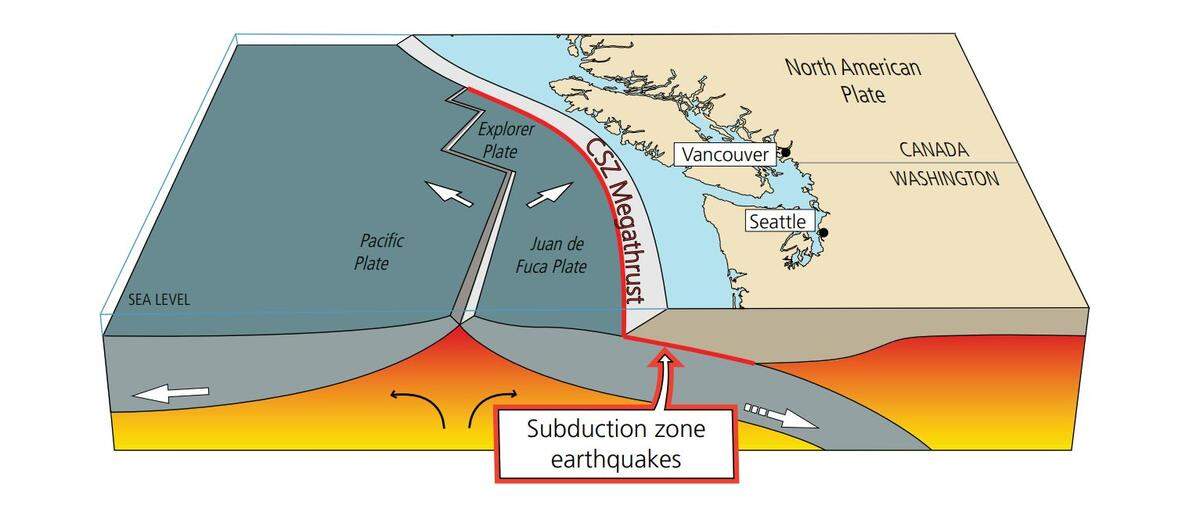
The last time it occurred was in 1700 — the Cascadia Megathrust Earthquake, which resulted in an earthquake of approximately 9.0 magnitude.
That was 323 years, putting us in the area period of when the next one will occur.
“I wouldn’t call that overdue, but I would certainly say that the conditions are there for an earthquake to happen on the Cascadia subduction zone,” Tobin previously said. “And I mean it literally, you know, it could be tomorrow, and it could be 100 years from now.”